Property Record
635 Smith Cemetery Rd, Winder, GA 30680


NEARBY LISTINGS FOR SALE OR LEASE
Property Detail
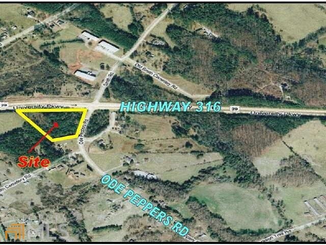
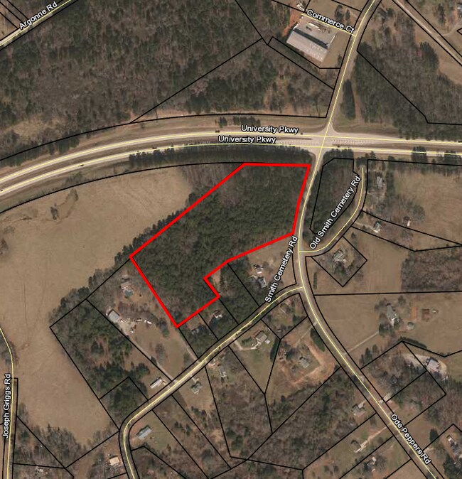
635 Smith Cemetery Rd
XX096-008
Rampeys Woods
Commercialacreage
HWY 316 & SMITH CEMETERY RD
X
Barrow
13013C0129D
Georgia
2024
11.80 AC
2025
Barrow County
180502
Atlanta
65,340 SF
Atlanta-Sandy Springs-Roswell, GA
DEMOGRAPHICS near 635 Smith Cemetery Rd
1 Mile
3 Mile
5 Mile
2024 Total Population
526
12,418
44,035
2029 Population
616
14,526
51,558
Pop Growth 2024-2029
+ 17.11%
+ 16.98%
+ 17.08%
Average Age
37
37
37
2024 Total Households
174
4,163
15,343
HH Growth 2024-2029
+ 17.24%
+ 17.15%
+ 17.23%
Median Household Inc
$70,416
$59,105
$60,092
Avg Household Size
2.90
2.90
2.80
2024 Avg HH Vehicles
2.00
2.00
2.00
Median Home Value
$212,500
$199,478
$207,164
Median Year Built
2003
1998
1999
Nearby Places
Map Layers
Map Styles
 Street
 Aerial
- Restaurants
- Banks
- Shops
- Fitness
- Groceries
SALE & LEASE HISTORY
LISTING DATE
SALE/LEASE

Jun 13, 2017
For Sale
Dec 18, 2019
For Sale
Nearby Properties
Address
Land Use
TOTAL SIZE
Lot Size
Zoning
Address
Land Use
TOTAL SIZE
Lot Size
Zoning
1,456 SF
1,732.80 AC
G
Address
Land Use
TOTAL SIZE
Lot Size
Zoning
275,840 SF
22.10 AC
M-1
Address
Land Use
TOTAL SIZE
Lot Size
Zoning
66,052 SF
30.20 AC
AG
Address
Land Use
TOTAL SIZE
Lot Size
Zoning
85,000 SF
85.90 AC
AC
Address
Land Use
TOTAL SIZE
Lot Size
Zoning
6,928 SF
358.90 AC
AC
Address
Land Use
TOTAL SIZE
Lot Size
Zoning
27,337 SF
60 AC
M-2
Address
Land Use
TOTAL SIZE
Lot Size
Zoning
20,132 SF
56.30 AC
M-2
Address
Land Use
TOTAL SIZE
Lot Size
Zoning
81,934 SF
30.90 AC
M-2
Address
Land Use
TOTAL SIZE
Lot Size
Zoning
6,960 SF
46.90 AC
M-2
Address
Land Use
TOTAL SIZE
Lot Size
Zoning
3,370 SF
352.40 AC
G,TNPD
Address
Land Use
TOTAL SIZE
Lot Size
Zoning
37,162 SF
4.60 AC
R-3
Address
Land Use
TOTAL SIZE
Lot Size
Zoning
3,462 SF
10.10 AC
G,R-3
Address
Land Use
TOTAL SIZE
Lot Size
Zoning
26,802 SF
5 AC
AG
Address
Land Use
TOTAL SIZE
Lot Size
Zoning
20,857 SF
39.60 AC
M-1
Address
Land Use
TOTAL SIZE
Lot Size
Zoning
24,982 SF
16.10 AC
R-1
Address
Land Use
TOTAL SIZE
Lot Size
Zoning
46,339 SF
2 AC
B-2
Address
Land Use
TOTAL SIZE
Lot Size
Zoning
85,290 SF
29.10 AC
C-3
Address
Land Use
TOTAL SIZE
Lot Size
Zoning
20,592 SF
66.10 AC
G
Address
Land Use
TOTAL SIZE
Lot Size
Zoning
76,768 SF
19 AC
AG
Address
Land Use
TOTAL SIZE
Lot Size
Zoning
67,000 SF
20 AC
AC
Address
Land Use
TOTAL SIZE
Lot Size
Zoning
45,296 SF
8.20 AC
B-2
Address
Land Use
TOTAL SIZE
Lot Size
Zoning
143,025 SF
9.30 AC
M-1
Address
Land Use
TOTAL SIZE
Lot Size
Zoning
7,000 SF
10.70 AC
G
Address
Land Use
TOTAL SIZE
Lot Size
Zoning
49,920 SF
24.50 AC
AG
Address
Land Use
TOTAL SIZE
Lot Size
Zoning
40,950 SF
32.90 AC
M-2
Address
Land Use
TOTAL SIZE
Lot Size
Zoning
11,914 SF
6.90 AC
G,R-2,R-3
Address
Land Use
TOTAL SIZE
Lot Size
Zoning
5,525 SF
10.80 AC
R-3
Address
Land Use
TOTAL SIZE
Lot Size
Zoning
38,423 SF
4.10 AC
R-1
Address
Land Use
TOTAL SIZE
Lot Size
Zoning
10,125 SF
63.60 AC
M-2
The World's #1 Commercial Real Estate Marketplace
Connect with us
© 2025 CoStar Group
The information above has been obtained from sources believed reliable. While we do not doubt its accuracy we have not verified it and make no guarantee, warranty or representation about it. It is your responsibility to independently confirm its accuracy and completeness. Any projections, opinions, assumptions, or estimates used are for example only and do not represent the current or future performance of the property. The value of this transaction to you depends on tax and other factors which should be evaluated by your tax, financial, and legal advisors. You and your advisors should conduct a careful, independent investigation of the property to determine to your satisfaction the suitability of the property for your needs.